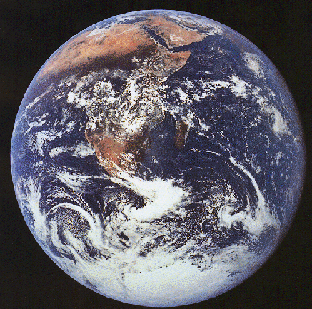
| Earth as a Planet Key points: Interior structure of Earth; differentiation; plate tectonics; getting and retaining an atmosphere (From NASA, APOD: http://antwrp.gsfc.nasa.gov/apod/ap950622.html)
|
 |
| Earth as a Planet Key points: Interior structure of Earth; differentiation; plate tectonics; getting and retaining an atmosphere (From NASA, APOD: http://antwrp.gsfc.nasa.gov/apod/ap950622.html)
|
|
 |
==> Because we live on Earth, we know the most about it,
and it forms the cornerstone of our knowledge in comparative planetology, where we
try to understand planets in depth by comparing their behavior with that of the earth.(From
C. Mayhew and R. Simmon, http://visibleearth.nasa.gov/cgi-bin/viewrecord?5826)
- a recommended site. To see the full movie:
|
Average density of the earth: 5.52 grams/cm3. The surface rocks have much lower density, about 3.3 grams/cm3, so the interior must have much more dense material (compared with 1.00 grams/cm3 for H2O, 2.7 grams/cm3 for Al (aluminum), 7.8 grams/cm3 for Fe (iron))
Most of what we know about the interior has been deduced from seismic wave data rather than direct measurement. When an earthquake occurs, it sends waves through the earth that reappear at the surface. The way these waves are modified in their travels through the center of the earth can be used to tell what the interior is like.
 |
For example, we can map the size of the liquid core by studying the types of waves. Liquids cannot support the side-to-side motions that make S-waves, while P-waves can travel through both liquids and solids. |
P-wave |
|
 |
|
S-wave |
 |
The size of the liquid core is measured by seeing where the S-waves
disappear, while the nature of the core (type of material, liquid or solid) can be studied
by seeing how the P-waves are refracted (a process
that works with earthquake as well as light waves) as they enter and pass through it. The
inner, solid core is deduced from refraction of P-waves due to their much higher velocity
in the solid than in the liquid (animation by G. Rieke). The
actual propagation of earthquake waves is very complex, producing complex
"seismograms" for such studies Many
more details of earthquake, or "seismic" waves expand on this picture |
Seismic studies have been refined to provide a high degree of accuracy in this picture, as well as many more details.
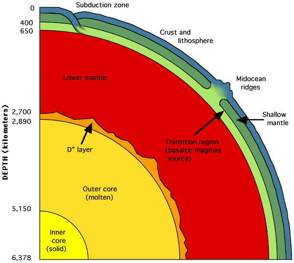 |
The core region is very hot, about 6500K (warmer than the surface of the sun!). The core is largely liquid metal, but the high pressure makes the inner core turn to solid despite the high temperature. The heat is a combination of energy trapped at the time of formation and energy released by radioactive decay. (From Calvin Hamilton, Solar Views, http://www.solarviews.com/cap/earth/earthfg2.htm)
|
 |
A trend in the earth's interior Deeper ===> find higher density materials This is the result of differentiation -- a process driven by gravity. When a planet is young and hot enough to be semi-molten, denser materials (shown in black) sink to the center and lighter materials float higher up. As the planet cools, it solidifies but can be left with a hot, molten (or solid) metallic core and a surface of relatively low density, light rock (the crust) "floating" on a thick semi-molten zone (the mantle). (animation by G. Rieke) |
|
|
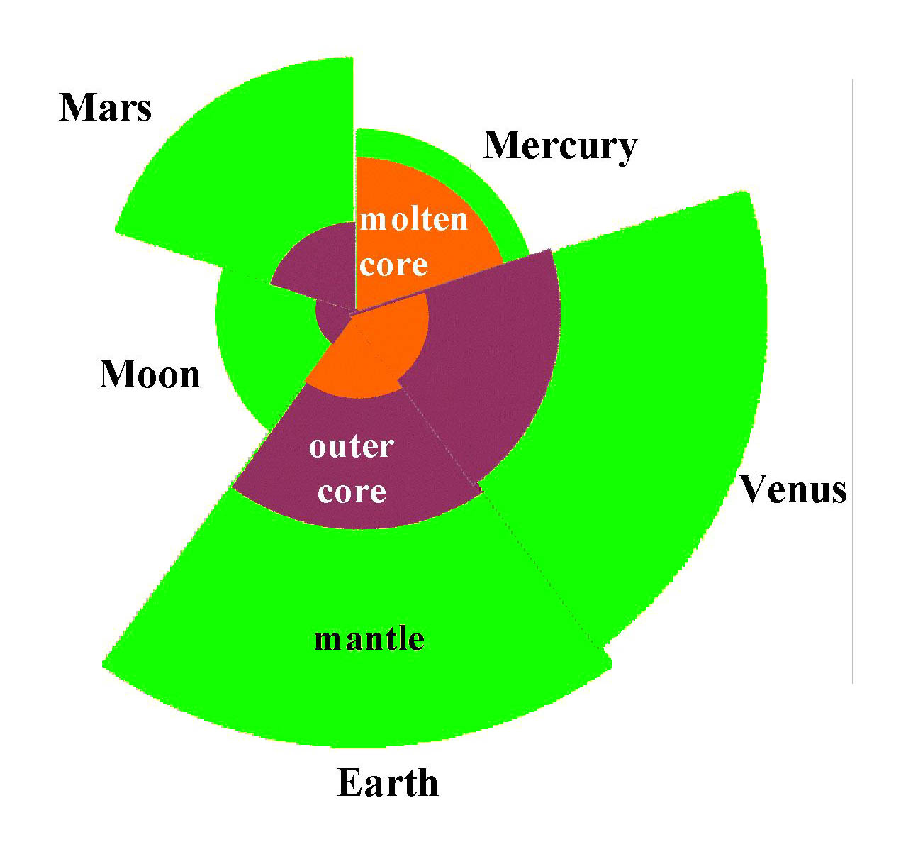
The interiors of the other terrestrial planets are similar to that of the earth, although Mars has cooled so far its core is no longer molten. The composition of the moon is similar to that of the crust of the earth, and any formerly molten core has also cooled and solidified. In general, small bodies cool more quickly than large ones because there is less material around their cores to trap the heat of their formation. |
The molten core and trapped heat in the center of the earth produce some
interesting consequences, such as plate tectonics and magnetism ![]() .
.
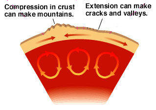
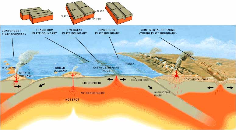
Because the earth's crust floats on the mantle and because the mantle is
plastic (that is, semi-liquid), the crust can move around. The movements are slow and were
not noticed until relatively recently. ![]()
The crust is subdivided into plates. These plates can move as separate objects on the mantle. They can bump into each other or they can move apart.
 |
Early evidence for plates came from noticing how the edges
of continents look almost like pieces of a jigsaw puzzle that should fit together (from Tripod, http://r80f51.tripod.com/id2.html).
|
 |
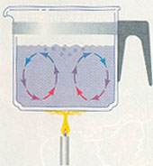 |
Convection in the hot rock in the mantle makes the plates
move (far left). (From The Essential Cosmic Perspective, Bennett et al.) The process is similar to a "rolling boil" in a pot of water (left). |
 |
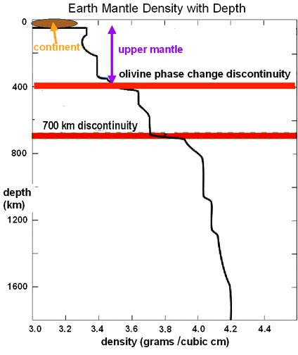
| Here is a simulation of convection in the mantle of the earth. Hot rock (yellow) rises and cool rock (blue) falls. The rock is at 1000 to 2000o C and creeps slowly; the rate of motion is a few centimeters per year (the simulation shows millions of years). The convection occurs because of the slow change of density with depth in the upper mantle, and between the 700 and 400 km discontinuities. As a result, a hot zone of rock at the bottom of one of these zones expands enough so its density becomes less than that of the surrounding rock and it rises, or floats, toward the surface of the earth. (From G. Houseman, Monash University Earth Sciences, http://www.earth.monash.edu.au/~greg/Conv.html) |
 |
The crust spreads along mid- ocean ridges, and molten rock flows in and fills the void helping the spreading to continue (figure from http://volcano.und.nodak.edu/vwdocs/vwlessons/lessons/Plates/Plates3.html, Volcano World) |
 |
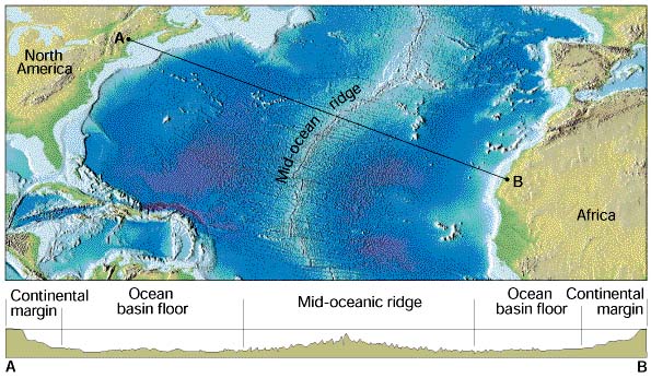 |
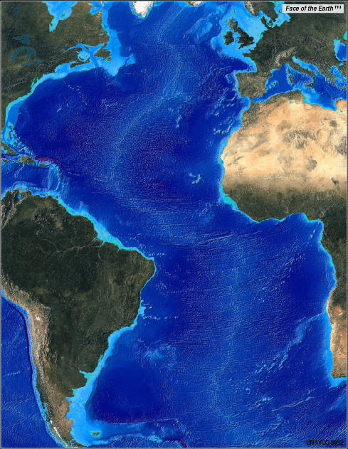
The animation to the left shows a crack where hot molten rock escapes from the interior and pushes apart the surface in opposite directions from the crack. (From USGS, http://wrgis.wr.usgs.gov/docs/usgsnps/animate/pltecan.html). The image on the right shows how such a crack, a "mid-oceanic ridge", runs right down the center of the Atlantic Ocean and powers the spreading of the ocean floor to separate the Americas from Europe and Africa. (from Alan Colville, http://www.calstatela.edu/faculty/acolvil/index.html) |
|
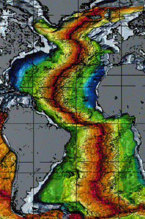 |
Various arguments let scientists determine the age of surface rocks. Here is a map of the floor of the Atlantic Ocean, with the youngest in red, shading to orange, yellow, green, and blue for progressively older ones. The blue rocks date to the Jurassic age, 150 - 200 million years ago, and show when the Atlantic started to grow. (From the University of California at Berkeley, Museum of Paleontology, http://www.ucmp.berkeley.edu/tectonics/atlantic.html) |
Due to plate tectonics, the earth's surface has been cycled up and down through the crust and any old structures will have disappeared. Wind and water erosion further heighten changes in the earth's surface. 750 million years of drift are shown below:

(Animation from the University of California at Berkeley, Museum of Paleontology,http://www.ucmp.berkeley.edu/geology/tectonics.html)
| This map (from National Geophysical Data Center) shows plate edges in yellow and epicenters of strong earthquakes in red. It shows the plates very clearly. | 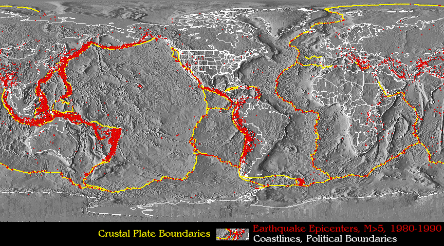 |
 |
Much of the geology of the earth is driven by processes at plate
boundaries and by the upwelling of magma at hot spots and rifts through the plates. These
motions keep raising the continents, which otherwise would slowly be eroded away and
eventually would submerge below the ocean level. In fact, there is enough water to cover
all the earth - so without tectonic plate motions we would all be under water. (from Wikepedia, http://en.wikipedia.org/wiki/Image:Tectonic_plate_boundaries.png)
|
The combination of the earth's distance from the sun and the character of the atmosphere is what makes the earth habitable.
| nitrogen | 78% | |
| oxygen | 21% | Maintained by plants from CO2 |
| argon | 0.9% | |
| carbon dioxide | 0.03% | Greenhouse gas |
| water | 0.1-3% | Greenhouse gas |
| ozone | trace | Important to absorb UV from sun |
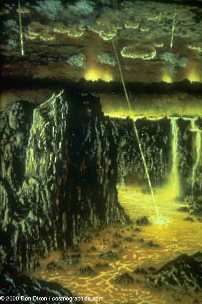 |
Materials for the atmosphere were brought to the earth by comets accreted during its formation, then released by volcanoes (From Don Dixon http://cosmographica.com/gallery/index.html). Additional late-arriving comets would have added additional material to the oceans and atmosphere. |
Hydrogen and helium were quickly lost to space because of gravity of the earth was insufficient to hold them, given the temperature of the atmosphere.
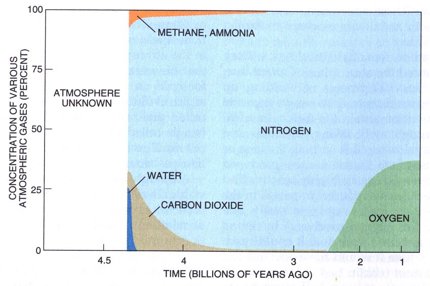 |
( From http://tefficks.dhs.org/~mia/atmosphere.htm) We know from fossil and geologic evidence that the earth's early atmosphere had much less oxygen and much more CO2. |
Three processes which changed the composition:
| 1) Continued volcanic activity -- volcanoes spew out water vapor, CO2, nitrogen |
| 2) Chemical reactions -- rain water and CO2 combine to form carbonic acid which can be trapped in rocks |
| 3) Photosynthesis -- plants take in CO2 and exhale O2
(the rise of plants is obvious in this plot of the composition of the
atmosphere versus age) |
For an unconventional review of the course up to here (and
maybe a bit beyond), try looking at it in postage stamps![]()
Test your understanding before going on![]()

Pioneering space art by Chesley Bonestell, http://www.bonestell.org/, http://www.dreamstone.com.au |
|
Thoth, Egyptian moon god http://www.startistics.com/ophiuchus/familyalbum.htm |
Click to return to syllabus |
||
| Click to return to Exploring Planets | hypertext |
Click to go to the moon (not literally!) |
