 Secrets
of Ancient Navigation
Secrets
of Ancient Navigationby Peter Tyson
Oak and triple bronze must have girded the breast of him
who first committed his frail bark to the angry sea
--Horace, Odes
"Aye, mate." One can almost hear the weary assent of countless a hoary sailor
upon hearing these words of Horace, almost see the rheumy eye staring distantly as if at
some ghost ship on the horizon that only he can see. For the old poet's words ring only
too true. In the three or four millennia of seafaring before John Harrison came along, how
could mariners know where they were going? The sea is literally without landmarks to guide
by, a vast, featureless emptiness ready and more than willing to swallow up the lost and
unlucky, leaving no trace save the awful memories of those who survived them.
The first seafarers kept in sight of land; that was the first trick of navigation. Follow
the coast. To find an old fishing ground or the way through a shoal, one could line up
landmarks, such as a near rock against a distant point on land; doing that in two
directions at once gave a more or less precise geometric location on the surface of the
sea. Sounding using a lead and line also helped. "When you get 11 fathoms and ooze on
the lead, you are a day's journey out from Alexandria," wrote Herodotus in the fourth
century B.C. The Greeks even learned to navigate from one island to the next in their
archipelago, a Greek word meaning "preëminent sea." They may have followed
clouds (which form over land) or odors (which can carry far out to sea).
But what if land were nowhere nearby? The Phoenicians looked to the heavens. The sun
moving across the commonly cloudless Mediterranean sky gave them their direction and
quarter. The quarters we know today as east and west the Phoenicians knew as Asu
(sunrise) and Ereb (sunset), labels that live today in the names Asia and Europe.
At night, they steered by the stars. At any one time in the year at any one point on the
globe, the sun and stars are found above the horizon at certain fixed "heights"
-- a distance that mariners can measure with as simple an instrument as one's fingers,
laid horizontally atop one another and held at arm's length. The philosopher Thales of
Miletos, as the Alexandrian poet Kallimachos recorded, taught Ionian sailors to navigate
by the Little Bear constellation fully 600 years before the birth of Christ:
Now to Miletos he steered his course
That was the teaching of old Thales
Who in bygone days gauged the stars
Of the Little Bear by which the Phoenicians
Steered across the seas
The Norsemen had to have other navigational means at their disposal, for in summer the
stars effectively do not appear for months on end in the high latitudes. One method they
relied on was watching the behavior of birds. A sailor wondering which way land lay could
do worse than spying an auk flying past. If the beak of this seabird is full, sea dogs
know, it's heading towards its rookery; if empty, it's heading out to sea to fill that
beak. One of the first Norwegian sailors to hazard the voyage to Iceland was a man known
as Raven-Floki for his habit of keeping ravens aboard his vessel. When he thought he was
nearing land, Raven-Floki released the ravens, which he had deliberately starved. Often as
not, they flew "as the crow flies" directly toward land, which Raven-Floki would
reach simply by following their lead.
 Heeding the flightpaths of birds was just one of numerous haven-finding methods employed
by the Polynesians, whose navigational feats arguably have never been surpassed. The
Polynesians traveled over thousands of miles of trackless ocean to people remote islands
throughout the southern Pacific. Modern navigators still scratch their heads in amazement
at their accomplishment. Like Eskimos study the snow, the Polynesians watched the waves,
whose direction and type relinquished useful navigational secrets. They followed the faint
gleam cast on the horizon by tiny islets still out of sight below the rim of the world.
Seafarers of the Marshall Islands built elaborate maps out of palm twigs and cowrie
shells. These ingenious charts, which exist today only in museums, denoted everything from
the position of islands to the prevailing direction of the swell.
Heeding the flightpaths of birds was just one of numerous haven-finding methods employed
by the Polynesians, whose navigational feats arguably have never been surpassed. The
Polynesians traveled over thousands of miles of trackless ocean to people remote islands
throughout the southern Pacific. Modern navigators still scratch their heads in amazement
at their accomplishment. Like Eskimos study the snow, the Polynesians watched the waves,
whose direction and type relinquished useful navigational secrets. They followed the faint
gleam cast on the horizon by tiny islets still out of sight below the rim of the world.
Seafarers of the Marshall Islands built elaborate maps out of palm twigs and cowrie
shells. These ingenious charts, which exist today only in museums, denoted everything from
the position of islands to the prevailing direction of the swell.
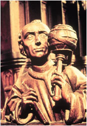 Statue of
Ptolemy. Statue of
Ptolemy. |
Charts have aided mariners ever since the Alexandrian astronomer Ptolemy created the
first world atlas in the second century A.D. The redoubtable Ptolemy even plotted latitude
and longitude lines on his atlas's 27 maps, though the farther one got from the known
world centered on the Mediterranean, the dangerously less reliable they became. Even
before Ptolemy, there were sailing directions -- the Greeks called them periplus or
"circumnavigation" -- that were compiled from information collected from sailors
far and wide. One of these, The Periplus of the Eritrean Sea, a document written in
the first century by a Greek merchant living in Alexandria, described trading routes as
far east as India. By the 10th century, Italian-made portolans supplied detailed
directions, distances, depths, and coastal descriptions, and by the 13th century, sea maps
with scale and bearings began to appear.
The greatest advance in navigation came with the compass. The Chinese apparently knew
about the powers of magnetism as early as the third millennium B.C., when, historians tell
us, one army defeated another after the battlefield had become enveloped in dense fog by
using a device known as a "point-south carriage." This was a standard carriage
for carrying royalty with a small, rotating figure mounted on the front, which by
magnetism always pointed south. (The Chinese chose to have the arrow point south rather
than north.) But no one seems to have manipulated the lodestone for sea navigation until
early in the present millennium. The first mention of the compass in the West comes from
the Englishman Alexander Neckham, who wrote in 1187 that "sailors use a magnetic
needle which swings on a point and shows the direction of the north when the weather is
overcast." Despite its usefulness, the compass took a long time to come into wide
use, as many seamen thought it operated by black magic. (Hence the invention of the
binnacle, in which sea captains could hide their recondite instrument from the suspicious
eyes of the crew.) In the meantime, sailors relied on natural forces they could readily
comprehend.
One of these was currents. From time immemorial, journeys have been made or broken by
these undersea winds. The western-trending currents of the Indian Ocean, for one, are
likely responsible for the Indonesian-based race of Madagascar, an African island 4,000
miles from the nearest bit of Indonesia. Similarly, the clockwise currents in the North
Atlantic helped doom one of the greatest land scams in history: Erik the Red's
colonization scheme for the island he cleverly dubbed "Greenland." Of the 25
ships that sailed west from Norway in the year 990, only 14 arrived. The father of those
North Atlantic currents -- the Gulf Stream -- was named by none other than Benjamin
Franklin. While deputy Postmaster-General of Great Britain in the 18th century, Franklin
noticed that his mail ships to the American colonies took longer than whaling ships.
Questioning whalers, he learned of a powerful current originating from the Gulf of Mexico
-- hence his name for it -- and sweeping northeast into the North Atlantic (and,
incidentally, giving the British Isles a climate positively balmy for such a northern
latitude).
Like currents, trade winds have always been important to mariners. Those blowing heads on
yellowed old maps were not mere decoration. In the Indian Ocean, for example, Indian
traders over the ages have ridden the northeast monsoon to Africa in the cool, dry winter
and taken the southwest monsoon back to the subcontinent in the hot, wet summer. To make
their annual voyages from Tahiti to Hawaii, a journey of several thousand miles, the
Polynesians hitched a ride on the prevailing south-easterly wind, setting a starboard tack
and sailing northeast.
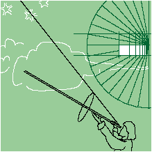
For millennia, as sailors from the Phoenicians to the Polynesians knew, the heavens remained the best way to find one's north-south position. Increasingly sophisticated devices were designed over the centuries to measure the height of the sun and stars over the horizon. The gnomon or sun-shadow disk operated like a sundial, enabling the user to determine his latitude by the length of the sun's shadow cast on a disk floating level in water. The Arabian kamal was a rectangular plate that one moved closer or farther from one's face until the distance between the North star and the horizon exactly corresponded to the plate's upper and lower edges. The distance the plate lay away from the face -- measured by a string tied to the center of the plate and held at the other end to the tip of the nose -- determined the latitude.
 |
In the Middle Ages, sailors relied on the astrolabe, a disc of metal that
one held suspended by a small ring. The disc had a scale with degrees and a ruler for
measuring the height of an astronomical body. Other medieval mariners preferred the
cross-staff, a T-shaped device whose base was held up to the eye. One measured the sun's
height by pulling the slidable top of the T toward one's eye until the sun lay at the top
and the horizon at the bottom. The quadrant required two operators, one to sight the sun
along one side of the device, and a second to read the angle marked by a weight hanging
from the apex of the instrument. Since blindness resulted from frequent use, the explorer
John Davis invented the back-staff in 1595, which enabled one to get the same measurement
with one's back to the sun.
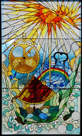
A stained glass window by Ria Kriek in the maritime museum in Mossel Bay, South Africa depicts three early nagivational instruments, the astrolabe to the upper left, the drawing compass (used to measure positions on charts) to the upper right, and the quadrant below with a navigator taking a sighting. The window was assembled as part of the 500th year celebration of the Portuguese navigator Bartolomeu Dias rounding the Cape of Good Hope, the southernmost coast of Africa, in 1488. (photo by G. Rieke) |
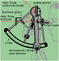 The sextant The sextant
|
The sextant was the most advanced of these devices, allowing users to determine their latitude to within a sea mile or two, even from a swaying deck. In the years after the sextant was invented in 1731, many held out hope that it would aid in east-west navigation as well -- that is, in finding longitude. Sailors could employ the sextant to figure longitude using the lunar-distance method, but with the astronomical tables of the 18th century, the process could take several hours to work out one's position -- not remotely good enough for sea travel. In the end, it was the dogged clockmaker, John Harrison, who solved the longitude problem with his chronometers. And today, the precocious step-child of these highly accurate clocks, the Global Positioning System, has finally proved the Roman dramatist Seneca right, when he wrote in the first century that
There will come an age in the far-off years
When Ocean shall unloose the bonds of things,
When the whole broad earth shall be revealed . . . .
Peter Tyson is Online Producer of NOVA.
Photos: (1,2) NOVA/WGBH; (3) Visuals Unlimited/Owon Gingerich.