 |
(to left, from SEDS, http://www.seds.org/nineplanets/nineplanets/mars.html above, Mangala, the planet Mars, depicted as a red-skinned horseman on a white ram. from The Black Peacock, http://www.goloka.com/index.html)) |
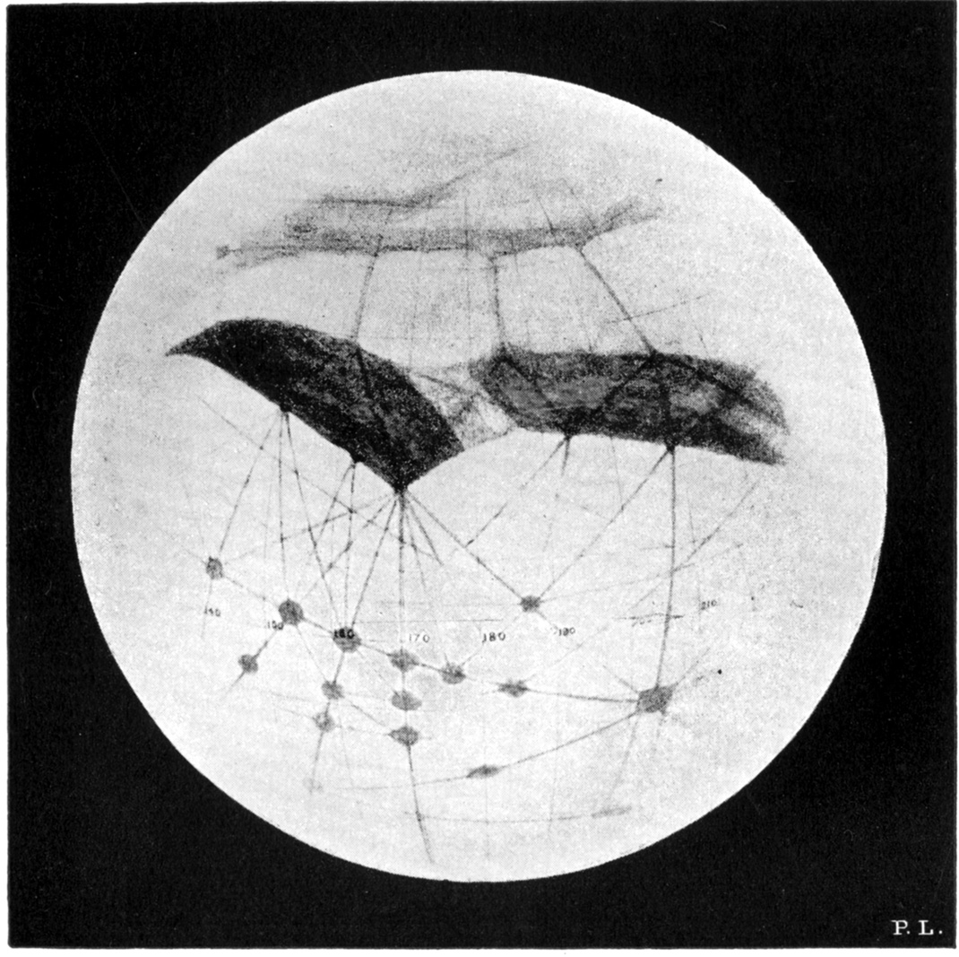
Key points: The mirage of Martian canals; comparison of Mars with Earth; evidence for water, search for life
|
(to left, from SEDS, http://www.seds.org/nineplanets/nineplanets/mars.html above, Mangala, the planet Mars, depicted as a red-skinned horseman on a white ram. from The Black Peacock, http://www.goloka.com/index.html)) |
We now know that the polar caps are predominately CO2 and not water; the variations in mid-latitude features are due to seasonal dust storms. The infamous “canals” are the result of an optical illusion where the human brain likes to play “connect-the-dots”.
| Mars Orbiter missions in late '60s and early '70s revealed a barren and cratered landscape on Mars making life as we know it on Earth unlikely. However, the areas mapped first have turned out to be the oldest, least "interesting" of the whole Martian surface! |
|
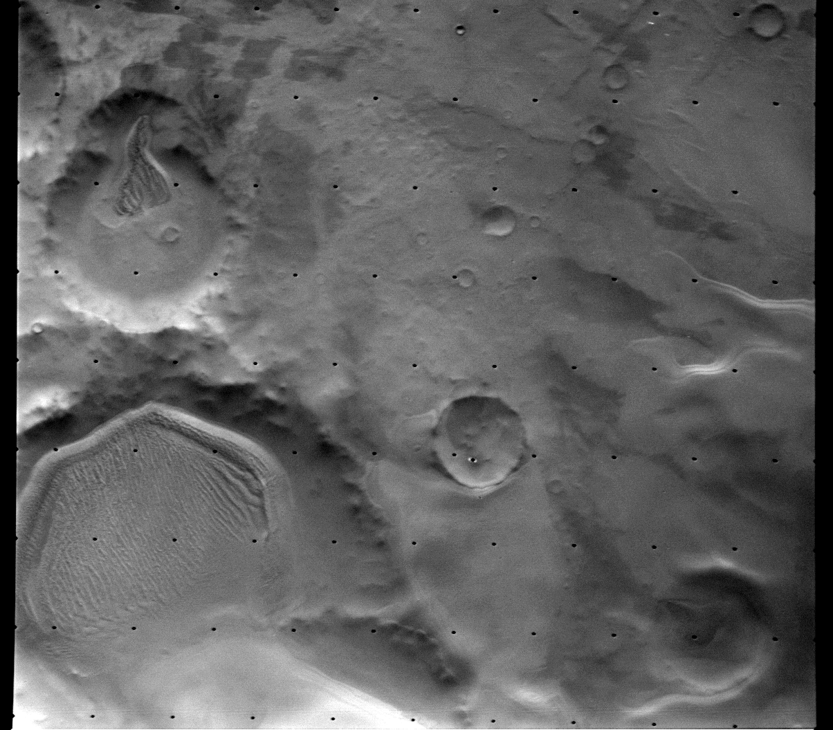
| Later missions have shown much more interesting terrain.
For example, Candor Chasma is a region containing many
landslides, fractured blocks that were probably at the bottoms of ancient lakes, and
craters partially buried by wind-blown sand. Volcanic deposits of lava are present
elsewhere in the canyon. (Image from NASA and NASM, http://www.nasm.edu/ceps/etp/mars/surface/canyons.html)
|
 |
This complex, in some ways earth-like, planetary surface has encouraged continued searches for life, but now on a bacterial and possibly extinct level - and also searches for water, as a necessary condition for formation of life. We will discuss these modern searches later, in the overall context of the formation of life. We now turn to the study of the planet itself.
Mars is smaller and less dense than the earth, and as a result has much lower surface gravity. The appearance of Mars is dominated by iron oxide (rust) that gives it a reddish color.
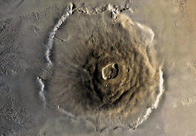
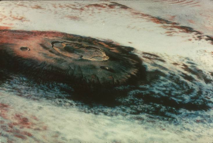
Mars has huge shield volcanoes, like those in Hawaii (such as Mauna Kea) -- Olympus Mons shown below is larger than any mountain on Earth,
 |
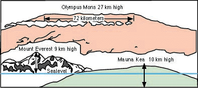 |
The Martian volcanos grew to huge size because there are no plate motions on Mars (From U. Tenn, http://csep10.phys.utk.edu/astr161/lect/mars/surface.html) We can trace this difference from the earth to the smaller size of the planet and its inability to retain sufficient interior heat to drive plates.
The lack of plate tectonics is confirmed by a lack of marsquakes that can be detected by various Martian lander spacecraft.
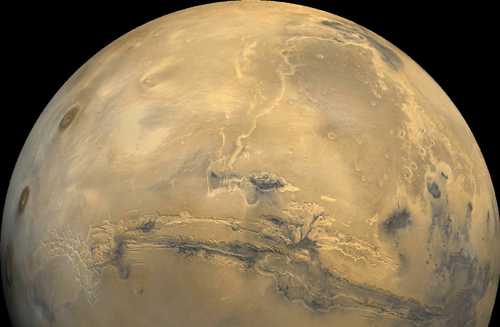
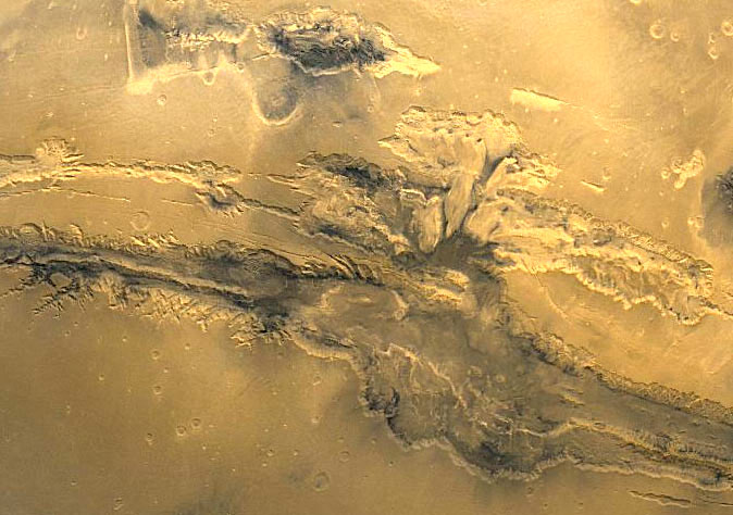
Mars also has a huge canyon, Valles Marineris, visible in the whole-disk image at
the top, in the view to the below left, and the artist's concept to the below right. (from
NASA, http://www.units.muohio.edu/dragonfly/space/VALLES.shtml,
Robert Hurt, http://homepage.mac.com/rhurt/gallery/latest.html).
It is far larger than the Grand Canyon. Here is an imaginary flight over
these features Caution! Large File!!
![]() (from http://themis.asu.edu/valles_video Mars
Odyssey Mission Thermal Emission Imaging System, ASU and JPL Digital Image Animation
Laboratory) If you missed the movie, or want to review what you saw, look here
(from http://themis.asu.edu/valles_video Mars
Odyssey Mission Thermal Emission Imaging System, ASU and JPL Digital Image Animation
Laboratory) If you missed the movie, or want to review what you saw, look here ![]()
 |
 |
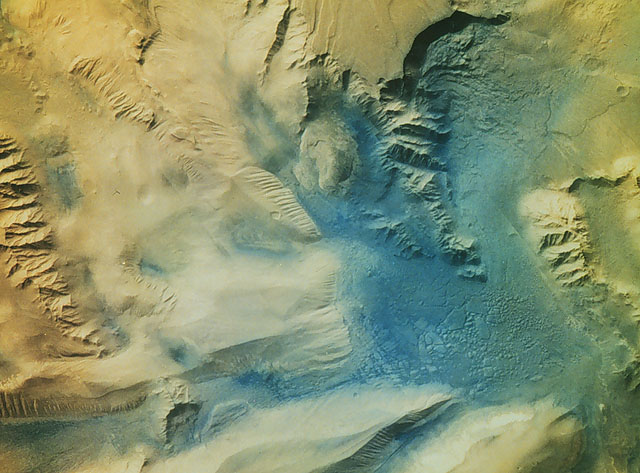
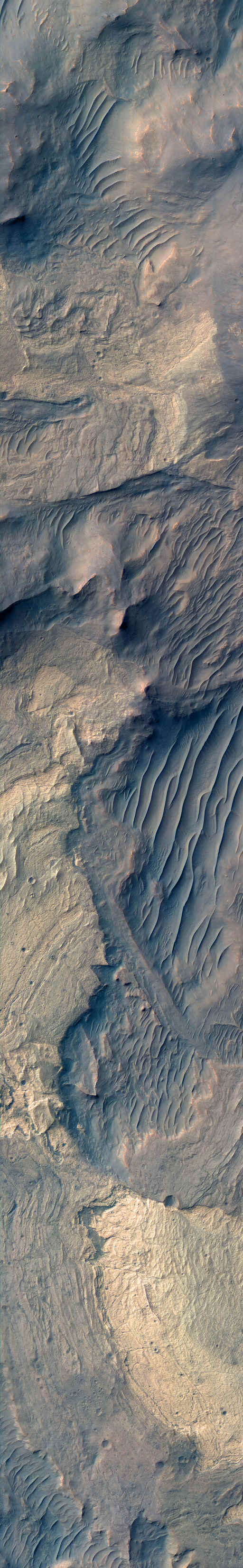
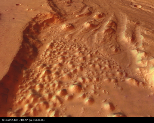
The background image to the extreme right covers a small portion of the floor of Ius Chasma, one branch of the giant Valles Marineris system of canyons. The image illustrates a variety of processes that have shaped the Martian surface. There are bedrock exposures of layered materials, which could be sedimentary rocks deposited in water or from the air. Some of the bedrock has been faulted and folded, perhaps the result of large-scale forces in the crust or from a giant landslide. (from HiRise operations center, U. of Arizona: http://hiroc.lpl.arizona.edu/images/TRA/)
The escape velocity from the surface of Mars is less than 1/2 that on Earth. The atmosphere’s density is about 1/200th that on Earth. As we would expect given the low escape velocity, the atmospheric composition is dominated by heavier gases than for Earth -- CO2, Argon, H2O.
 |
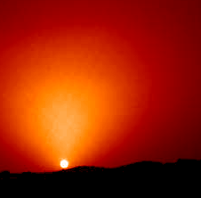 |
| Surface is extensively modified by winds,blowing dust. Notice streaks of dust from craters (left). Martian sunset from Mars Pathfinder (right) shows the effect of dust in the atmosphere: (http://www.spacedaily.com/news/mars-odyssey-01b.html) | |
| Thin clouds form in the atmosphere. http://www.ucls.uchicago.edu/students/projects/martiansuntimes/ |
 |
 |
Chart of temperatures from Mars Pathfinder -- a Sol is a
Martian day. Days are similar to Earth, seasons more extreme (and colder) because Mars’ orbit is more eccentric than the earth’s and Mars’ polar axis tilt is a little more than for the earth’s (25.2o as compared to Earth’s 23.5o) |
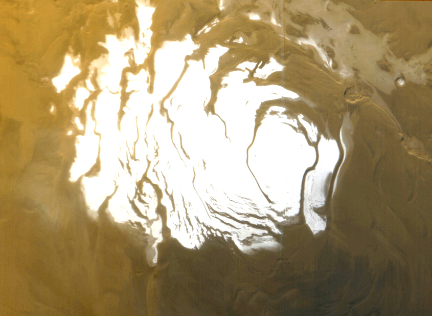 |
The polar caps (we show the south one here)
are frozen carbon dioxide (dry ice). They have a complex layered structure
from the cycles of melting and freezing. (Picture from Mars Global Surveyor, http://www.msss.com/mars_images/moc/4_27_00_spcap/index.html) |
Although the atmosphere and weather conditions do not seem conducive to life now, perhaps the lighter gases leaked away slowly. Is it possible that Mars started with Earth-like conditions, such as flowing water? If so, did life form then?
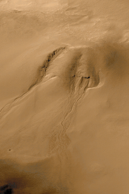
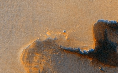
Valles Marineris and other geological features provide strong evidence for running water on surface in the past.
 |
 |
|
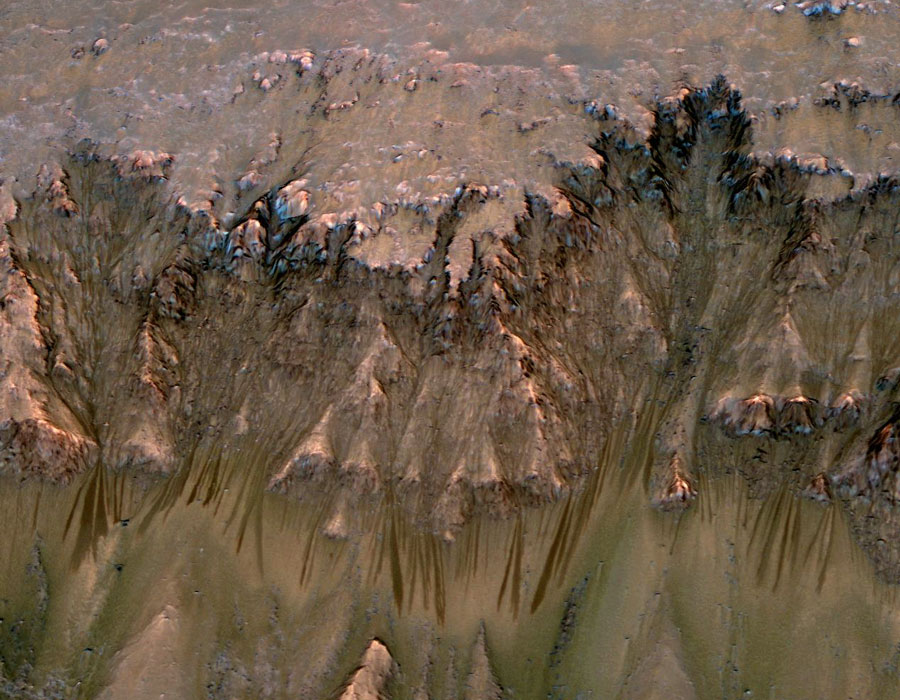
Probable erosion streaks on a cliff (above left)
(HiRise,
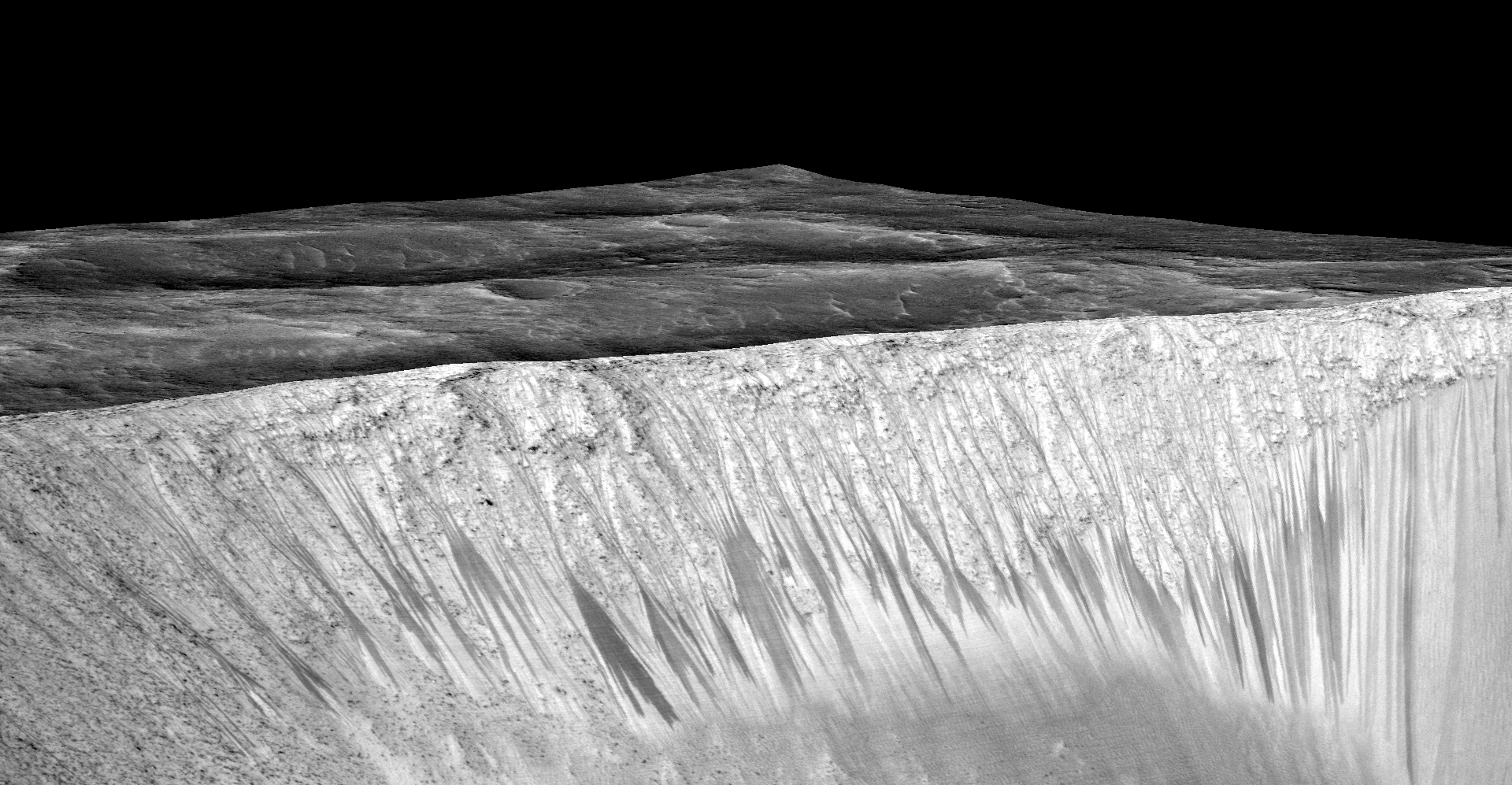
MRO; LPL (U Arizona), NASA) Probable ancient river bed (Mars Express, ESA) Gullies in a crater wall (left), from Mars Global Surveyor, http://www.msss.com/The_MOC_Shop/order_form The walls of the Garni Crater (below) are marked by dark narrow steaks, called "recurring slope lineae" by geologists. The streaks are a few hundred meters in length (a few football fields) and almost certainly are produced by recent flows or salty water. (credit NASA/JPL/University of Arizona, HiRise spacecraft, https://www.nasa.gov/multimedia/imagegallery/iotd.html) |
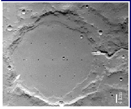 |
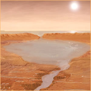 Crater (to left; diameter about 20 miles) that appears to have been a lake in the past. It has a very smooth, flat floor with "shoreline" markings and streams bringing water in and out as indicated by the arrows. (From Cabrol & Grin, 1999 Icarus); artist's concept (above) shows how it might have looked (from Berkeley Lab, http://www.lbl.gov/Science-Articles/Archive/SB-ESD-hunting-for-martians.html |
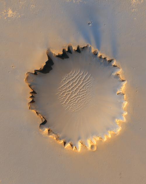
| This beautiful image of the Victoria Crater is from the HIRISE camera
(provided by the U. of Arizona) on the Mars Reconnaisance Orbiter. The original image can
distinguish details at the scale of a few feet. http://marsprogram.jpl.nasa.gov/mro/gallery/press/ The crater is about 800 meters (half a mile) in diameter. The distinctive scalloped shape of the rim is caused by erosion and downhill slides of crater wall material. Boulders that have fallen from the crater wall can be seen at the bottom of the crater. A striking field of sand dunes also lies on the crater floor. The Opportunity rover is perched on the rim of the crater at about the ten o'clock position. See the blow-up below for a better view of it.
|
 |
The Mars Odyssey mission has found that the planet used to have large amounts of water (using an instrument whose development was led by UA Professor Bill Boynton).
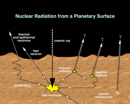 |
Here is how the Odyssey experiment works: When cosmic rays strike the surface of Mars, they can penetrate and react with the atomic nuclei trapped just below. The reaction produces gamma rays with energies characteristic of the atom that produced them. By measuring the gamma rays, we can tell what the atoms below the surface are. From Mars Odyssey home page, http://mars.jpl.nasa.gov/odyssey/ |
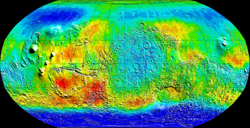 |
The surface areas colored blue show lots of subsurface hydrogen,
indicating the presence of water. Maybe they are telling us where Mars used to have
oceans! From Mars Odyssey home page, http://mars.jpl.nasa.gov/odyssey/ |
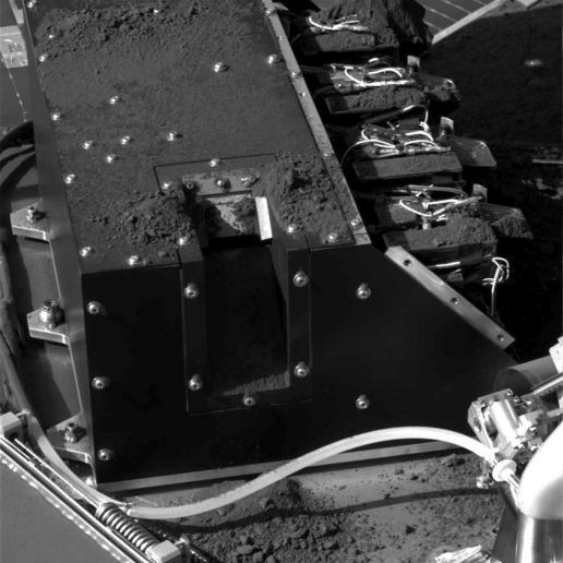 |
The Mars Phoenix mission (led by Peter Smith of the UA Planetary Sciences Department) confirmed the presence of water in Martian soil by landing on the surface, where it used this scoop to deliver Martian soil to an on-board device that heated it and analyzed the vapors it gave off. They included water that had been trapped in the soil. |
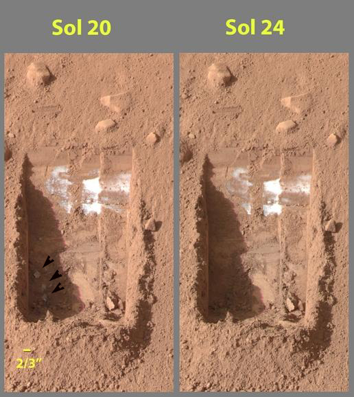 |
These pictures taken by Phoenix show the underground frost. The spacecraft scoop has cleared away some of the surface soil. Some lumps of material can be seen to the lower left in the trench on Sol 20 (indicated with three arrows). However, they have evaporated and disappeared by Sol 24 (Sol 20 and Sol 24 are days counted since the mission started taking data).,The white material is probably carbon dioxide frost deposited over the cold Martian night. |
 |
 |
 |
Conditions are similar enough to Earth that some have proposed ways we
might modify them to make Mars more habitable -- a process that has been named
"terraforming". Basically, the proposals are based on enhancing greenhouse gases
in the Martian atmosphere to raise the surface temperature. For an explanation of how it
might be done, see http://www.cem.msu.edu/~cem181fp/mars/chem-intro.html,
and many other web sites. It isn't clear at all that this is feasible, of course, nor that
it is desirable![]()
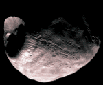
Mars has two moons, Phobos and Deimos, which probably are captured asteroids and did not form with Mars.(from NASA via http://sci.esa.int/science-e/www/object/index.cfm?fobjectid=31031)
 |
 |
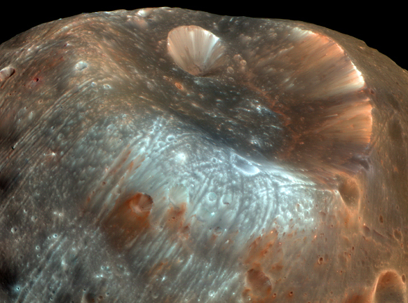 |
Here is a view of the large crater on Phobos, taken by the HiRise mission.The crater is 9 km (6 miles) across; its size suggests that the impact that created it must have come close to shattering the small moon. (from APOD, http://www.brera.mi.astro.it/apod/ap080410.html |
Test your understanding before going on![]()
 Mayan Venus deity, from
the Borgia Codex, http://members.shaw.ca/mjfinley/4VENUS.htm Mayan Venus deity, from
the Borgia Codex, http://members.shaw.ca/mjfinley/4VENUS.htm |
|
Marduk, associated with Jupiter by the Babylonians |
Click to return to syllabus |
||
| Click to return to Venus | hypertext |
Click to go to Jupiter |